Wednesday, August 20, 2014

John Muir Trail Hike 2014 - Second Leg

This entry is the second in a series of three documenting our trip to the Sierra Nevada mountains and the John Muir Trail.  The full picture set is available on Flickr.

After coming into town at the end of the last entry, we took a zero-day to figure things out and get set to go again. Our friends weren't going to be able to hike again for at least a few days due to blisters (we did talk them into buying heavier-duty boots) so we headed back out alone.  Instead of starting where we'd left off, we bought a ride further down the trail to a section noted for being particularly beautiful.

The drive alone took us past 9,000' in elevation and that was for the parking lot at the bottom of the pass (we learned on this trip that 'pass' means "mountain that isn't quite as tall as the ones next to it while also being flat enough to construct a trail on").  On the plus side, it was a nice, sunny day, and we got a reasonably early start.


 We were going over Piute Pass, which cannot be seen in this picture.  This is leading up to it.

 We felt that Piute Pass was probably the most scenic area of the trip.  We went up past several small lakes in a series of ever-higher valleys.

Eventually we passed above treeline and things got rockier.

 View from the summit.  We found the elevation was really slowing us down - we needed regular pauses to breathe for a bit.  We'd feel strong/normal for a few steps after each break and then the fog would start creeping back in.  Ana reported seeing stars on the periphery of her vision.  This is not normal for us hiking at lower altitudes.

Sure was pretty though.  For a while...

A few hours later, clouds rolled in, the temperature dropped sharply, and it started intermittently raining and hailing.  The largest hail was pea-sized and it definitely stung.  We soldiered through it for a while but after a couple hours we were soaked, chilly, and not making much progress so we called it a day and camped.  Ana, in trying to find a silver lining, noted that the hail, in slicing up the vegetation, made everything smell piney and herbaceous, which was pleasant but not a fair trade for the hail.

The next morning was dry, if cold, and we were glad we'd camped - the trail beyond that point was very rocky and exposed and would have been dangerous in addition to miserable in the rain.


We had a food shipment waiting for us at John Muir Ranch so we went a couple miles out of our way to pick it up.  Our friends had also shipped there and weren't going to pick it up so we opened both barrels and raided their bucket for goodies.  They'd spent more time than us thinking about food and we found a lot of new-to-us bars and snacks in there that added variety and interest to our diet (for instance, buffalo and cranberry bars).  We had a lot more than we could carry and were accused by other hikers of working for Pro-Bar as we attempted to give a huge pile of them away.  For the record, Pro-Bars are excellent fuel, but no matter how excellent they are we couldn't carry an extra 10lb of them through the mountains.  Ana was finding her new boots collected rocks and bought giraffe-print gaiters to keep those out. 

Muir Ranch, as a major resupply point for the JMT, has a major store of hiker goodies that people have left behind/donated to future hikers that are kept in buckets  (we needed a new bucket just for the Pro-Bars we left).  I ate three packages of jerky out of the donation bins as I was craving protein.  However, not all hikers are American and not all hikers donate recognizable food items.  Some other hikers who were resupplying got into a stash of Korean "fish bars" from the donation bins.  Someone brave ate one and declared it not bad, and then several people sampled them and came to largely the same conclusion - but shortly thereafter a hiker who could read the label came in and informed people that the 'bars' were actually soup mix.  I think the people eating them mostly shrugged and kept going, but it was pretty funny.  

We took much longer here than we needed for the resupply to dry out ourselves and our boots after the rain of the day before.

Deer are not afraid of people on the JMT.

That afternoon clouds formed again and as rain started coming down we ducked into cover in a grove of trees to wait out the hail and lightning, which was both heavy and close.  It ended after an hour or so and we continued in light rain and made decent time. 

The sun even peeked out over the mountains a little.

We made our intended campsite at Evolution Creek, did a really good PCT bag-hang (our bear canister was too full after the resupply to hold everything), and generally felt like things were going pretty well.

The next morning we had to do the one actual stream-fording of the whole adventure.  Fortunately the creek had dropped overnight and it was not deep.  It was, however, VERY cold.

Cold cold cold cold cold!

After crossing Evolution Creek, we hiked up into the Evolution Lakes area, which is one of the more scenic on the JMT.

I would say that it lived up to its billing but Piute is prettier.

The further we went the more numerous and darker the clouds got.

As we approached Muir Pass, which we wanted to cross and be well down the other side of by the end of the day, it started raining and thunder started rumbling around 2PM.  We really didn't want to climb another 1,500 feet into more exposed territory with virtually no camping spots into the teeth of a storm so we made camp and got under cover.  An hour later it looked like the storm had cleared up and we had almost completely struck camp before the clouds came back in and it started raining again.  We talked to hikers coming down from the pass and they said it was pretty ugly up ahead, especially on the other side of the pass, so we stayed put.  Stopping so far from our goal for the day meant the schedule was out the window and we'd have to exercise our abort path, but I asked myself "If I went up there and was injured or died, would people say That was completely unforeseeable or What a dope?" The answer was too close to What a dope so we stayed put.  Looking at the clouds over the pass, I felt increasing confidence in our decision as they were quite dark and enduring.  We had a lot of time to kill before the next morning and spent most of it asleep, though Ana also got some knitting done (she added a whole 4oz. to her weight budget for needles and yarn and carried them the whole way).

Wanted no part of that storm at nearly 12,000' without cover.

The next morning was clear and dry again so we scampered up the pass as best we could in the altitude.  We were still slow but substantially faster than before, closing in on 2 miles an hour uphill at elevation, which isn't too bad.

Muir Pass 

The lakes up there often seem very blue indeed.

Hut erected in memory of John Muir decades ago.  Still very solid.

This could definitely save your life in a storm.  Glad we hadn't been up here needing it the day before.

The other side going down was quite rugged but very pretty.

We walked down this postcard-perfect valley along the river.

Was still fairly steep in places.


We were hearing from hikers who had been in the valley the previous day that they'd gotten several inches of accumulated hail in the storm the previous day.  Remains of it inches deep could still be seen in the shadows in the warm midafternoon.  The rangers were saying the weather was going to stay bad and that the next day was going to be particularly wet.  We were seeing a very clear pattern where each day started clear, gradually got cloudy, and eventually dumped on us.  We had a sneaking suspicion that it was the same water each time as the clouds did not move - they formed directly overhead and simply dissipated after dumping their rain and hail on us.  However, the rangers were saying that tomorrow was going to bring in a storm system from outside.  We were exiting over Bishop's Pass and wanted to get as far along as we could before the weather turned sour.

This is a view from the other end of that valley, going up the side towards Bishop's Pass.

We found an enormous drift of accumulated hail on the trail, probably 8-10" deep.  Yikes.  Also, green pine needles were down everywhere, having been knocked off the trees by the hail.

This day was still looking pretty nice, but we stopped at the last marked campsite short of the pass anticipating another afternoon thunder-hailstorm....which never materialized.  Some weather-traumatized through-hikers who were aborting their trip across the pass looked at the sky like dogs expecting a beating.  The consensus was that it not raining today made everybody very nervous about tomorrow.  The through-hikers had been out for 14 days and reported that it had rained on 12 of them.  It should be noted that the JMT is supposed to be a classic summer hike specifically because of dry and temperate conditions.  The rangers confirmed that we'd been getting more than twice as much precipitation as usual and that it was looking to continue indefinitely.  We had a nice night talking with the other hikers and hanging out, which was much more fun that staying the tent for 13 consecutive hours the previous day.

This is similar to our reaction to hail thunderstorms - we stuck our toes in more really cold water in lieu of one this day.

We were awoken by a thunderstorm at 4 AM, thinking the worst case scenario had come to pass and we'd be rained on all day. When it was time to pack up and go (5:30 AM),  it was merely overcast and we wanted to make as many miles as possible before more rain arrived.

We walked upwards through Dusy Basin and it was quite scenic, but we didn't want to pause much.  We passed a gentleman who had come over the pass the night before, heard about today's hypothetical weather, and was headed right back out over the pass.

We saw spots of blue sky and sun in the distance but the clouds didn't dissipate.

As we summited the pass (just under 12,000' elevation) thunder rolled around us and Ana reminded me that if my hair stood on end the current best practice is to hunch over and grab my ankles, which is more likely to route the lightning strike through limbs rather than head and heart.  Thankfully we didn't need to employ this technique.  We did get hit by hail again...and again...and again (total of five times this day).


The first part of the down was very rocky, rugged and steep.  We were torn between getting the hell down away from the storm and not wanting to slip and fall.

It cleared up a bit and we got intermittent rain and hail on the way down but not soaking heavy rain after the summit.

One moment that will live forever for me that we experienced walking down Bishop's Pass was running into about four young gentlemen in hoodies and shorts who asked us "Have you seen any caves?  For in case it rains."  Having already been rained on several times that day, standing there stinking and damp in our rainproof coats, packs, boots, etc, it was hard to overstate the fact that there were no caves, that relying on caves was not a valid Sierra Nevada survival strategy, that given the weather they should not go up any further in altitude and in fact should return to their car as swiftly as due care allowed.  I didn't point it out at the time, but if one of them got hurt they had no way to keep that person warm until help could arrive.  They were only ~3 miles from the car but I hope they made it back down OK; we got rain and hail within minutes of speaking with them.


We at least made it to the parking lot intact. This was the abort exit. We were not expected to be there and of course couldn't get cell service, so walked another 1.5 miles to the first building with a pay phone.  We didn't have any luck contacting our friends but we loaned our phone card to another hiker and when his ride came in we got a free ride back to Mammoth Falls which was fantastic (otherwise a 23 mile walk plus an hour's bus ride - but we would have hitched or something at least to the first town).  In the meantime, since we were standing in the tiny store of a fishing resort, we learned a lot about high-altitude trout fishing from a few people obviously passionately dedicated to the sport.  We checked into a hotel, and will pick up the adventure there in a future entry.

Monday, August 18, 2014

John Muir Trail Hike 2014 - First Leg

Instead of going on vacation by simply ignoring our email and watching a Mythbusters marathon while eating ice cream, we devised a plan to go climb over some very tall and rugged mountains for our time off this summer with a couple of friends from undergrad.  Some of the time spent there was awesome and some was merely adventurous. This series of entries will document our time on the John Muir Trail through the Sierra Nevada mountains.  It should be noted this was not a through-hike - we did about a third of the miles of the overall trail in a few different sections, along with some additional miles getting to and from the main trail.  The complete picture set (including some taken by our friends) can be seen on Flickr.

Getting to the trail proved to be more challenging than expected.  We made the plane about two minutes before the door closed after waiting forever in the parking lot for a shuttle and having the check-in agent be perplexed by our luggage for some reason.  A person directly behind us on the plane claimed descent from at least one prominent Biblical figure and spent the entire flight discussing the relationship between the Bible and current events in Israel with the credulous lady next to him, thankfully I (Lee) slept through most of it (Ana was not as lucky).  After arriving in San Francisco, our driver (we hired a shuttle service to get to Yosemite) was two hours late.  Traffic outside the city slowed us down further, such that we arrived too late to pick up our backcountry permit that day. The drive in was our first introduction to the strange terrain we'd be spending the next several days in. The golden, rolling hills were very new and different for us as no member of our party had spent any meaningful amount of time in California outside of the cities.

We arrived in Yosemite, the part we were in wasn't on fire (though we could smell the smoke from the fires 10-15 miles away) and we had really plush accommodations, pictured below.  We ate a real dinner, bought gas canisters (can't fly with them) and Ana found me a replacement fleece for the one I'd accidentally left on the floor of the living room after taking it out to wear on the plane but not actually putting it on.


The problem with not getting the wilderness permit the day before was that our bus to the trailhead was scheduled to leave at 8:20 and the office to get wilderness permits only opens at 8:00AM.  Also, the place to get the permit is at least half a mile away from where the bus stops (the map shows almost a mile but I am certain it is less).  The plan we devised put the other three members of the party at the bus stop, while I (Lee - my name was on the reservation) went to the office to try to make it happen.  Since I was picking up a reserved permit instead of waiting in line for a new permit (they issue a very limited number of walk-in permits per day and people line up pre-dawn for them) I talked my way to the front of the line and waited.  They didn't even open the doors to the station until 8:05, and they really weren't interested in hurrying.  I suspect that I could have been more polite to the ranger, but they finally started the wheels turning and I got the first permit of the day around 8:19.  I ran (in hiking boots, through the smoke from the fires) and made the bus stop around 8:24 where thankfully a large group of confused tourist-grade hikers had delayed the departure of the bus.  We clearly squeaked by here.

 An area previously burned, with smoke in the background from one of the current fires (taken from the bus)

 Arriving at our stop, we walked a bit and took pictures at this lake shortly before the trailhead

As the Sierra Nevadas have substantial altitude, it is recommended to adapt to the air a bit before engaging with serious hiking.  Overnighting in Yosemite was a good start, but for the first day we had scheduled around 7 miles of hiking over fairly low, gentle terrain.  We definitely noted the effects of altitude when going uphill - flats and downs we could walk normally but uphill was more difficult than usual.  We had no real problems though, and made our highly scenic Glen Aulin campsite with plenty of light left, leading to a leisurely dinner and time to dip our toes in the river.

 View from the bridge across the river in front of the campsite

 The waterfall in front of the camping area 

The next morning it was a little gray-er but still dry and we started hiking.

 We encountered our first horse and mule trains - most of the trails are open to use with horses.

 This is the kind of natural beauty where we're not actually on a mountain.  This will become less common the further in the trip we go.

 After picking up a food drop and getting lunch (we crossed a road and you don't miss a chance to eat real food on the trail, even on the second day) we walked down this river valley and eventually picked a campsite.  It was steadily overcast and eventually started misting, but we didn't get too wet.

 Was cool enough that we put on some thermal layers under the rain coats.  I used the replacement fleece from Yosemite pretty much every day.

The next morning we hit the trail again and encountered loose horses, which we detoured around.

Also a pretty nice waterfall across the valley.


We also encountered the first real 'up' of the trip, across Donahue Pass.  We met some Boy Scouts coming down from the other side and got mixed reactions from them.  The Boy Scouts themselves were singing "1500 Bottles of Pop on the Wall" and were down to 67 bottles, so they seemed in good spirits.  The Troop Leader told us that we'd never make the pass today as it was too difficult.  Since we were planning to camp well beyond the pass and the mileage was pretty reasonable I did not pay him too much heed.

 Nice view of the river in the valley from above


It started raining (pretty moderate, not a soaking rain) and we needed to cross streams of varying sizes.

Some of which were in the trail and clearly existed only when it was raining.

The high lakes close to the pass were pretty otherworldly in the rain and fog.

 We summited Donahue Pass and started back down around 1PM.  So much for the Scout leader's prediction!

We had patches of clearer sky but the puddles in the trail slowed us considerably as we tried to avoid them without damaging the surrounding vegetation.  We were losing time going downhill.  We pushed through into the evening and eventually camped at Thousand Island lake, which was very pretty but also fairly cold and windy.  Ana was not feeling well, probably due to altitude sicknesses, and couldn't keep food down.  While both Ana and I had dry feet, both our friends had opted for lighter-weight boots and their wet feet had blistered somewhat, so we were feeling a little less cocky at this point.

View from Thousand Island Pass of Thousand Island Lake

The next morning we started off early with the goal of getting back to civilization in case Ana's altitude sickness didn't abate.  We needed to do 17-18 miles, but fortunately it was no longer raining and the terrain was not particularly challenging.  Ana got an altitude remedy from some older hippie ladies that allegedly used the active ingredient in coca leaves but it didn't seem to do anything (I suspect it was a fake / placebo anyway, as the real thing would probably be fairly illegal and not sold in stores).


The sun actually came out in the afternoon.  As the day went on Ana's altitude sickness abated but the blisters of our friends got worse.

We saw Devil's Postpile, which is apparently an internationally famous geological formation.

Bad signage took us on a ~1 mile detour right at the end of the day past this burned-out area.  Every single hiker we asked about the signage in this area made the same mistake we made - the arrow clearly pointed down the incorrect path.  Would have been a nice view if we didn't have the extra walk because of it.

Still, we made the last bus into town with about 7-8 minutes to spare.

And got some real food.  Ana ended up eating that night but she'd walked about 30 miles over two days between eating solid food.

We also saw a bear on the steps of the hotel that night, the only sighting of the entire trip.

More hiking adventure to come in the next entry.  As previously mentioned, the entire set of pictures is available on Flickr.

Thursday, July 24, 2014

Memphis Trip

Two weekends ago we drove down to Memphis to visit my (Lee’s) sister, who is currently working there with Teach for America.  We didn’t take a lot of pictures but some of what we did take might be of interest to the relatively small readership of this blog. We drove down Friday and ate out at Central BBQ which is apparently one of the more famous Memphis BBQ joints.  We had fun but the food wasn’t life-changing.  We went to bed at a reasonable hour to prepare for a full Saturday. Saturday we visited three places: the Civil Rights Museum, the Metal Museum, and the Memphis Zoo.  The Civil Rights Museum, which is based in the building that used to be the motel where MLK was killed, didn’t have too many surprises for us in terms of overall history but did offer a variety of personal perspectives and artifacts that were new.  We also appreciated the emphasis on the economic drivers for slavery.  I felt overall that the museum did a good job in contextualizing the different pieces and placing them into the larger narrative, and I was glad to have gone. After the museum we tried to get lunch at two separate BBQ places specializing in pulled pork sandwiches.  Unfortunately, nobody visits Memphis in the middle of July and both places were closed/on vacation.  We ended up going to a Venezuelan restaurant called Arepa and Salsa that served pulled pork (and chicken and beef) on fried plaintains in substitution for buns, with tomato and avocado and various sauces.  These proved to be admirable and interesting substitute lunch sandwiches. The Metal Museum is tiny place with a limited collection of things to look at, but what they did have was fun. The exhibits are more about art made with metal and less about metallurgy and materials science (which I was kind of hoping for) but for $4 admission I wasn’t exactly crushed. The special exhibit had a theme of basically ‘jewelry for doing violence to others or convincing them not to attempt to do violence to you’ and had things like ring sets that were secretly brass knuckles, porcupine-quill necklaces, and hair pins rather sharper than they needed to be. The Metal Museum also featured demonstrations of blacksmithing and casting, both of which I had never seen before in person.  Ana was less impressed since apparently she talked a high school teacher into letting her sand-cast some parts in the school machine shop at one point, which to my understanding is not a common practice. 


The Metal Museum is also right next to the Mississippi, which I took a picture of.  This trip was the first time crossing it not in an airplane for Ana and I.  The website shows some of the exhibits if you actually wanted to peek at the contents of the museum. 


The zoo was a zoo, but a pretty nice one.  The only pictures I took were of the frightening and unpredictable creature below.  Going to the zoo late in the day was a good idea as it wasn’t too hot and sunny, the crowds were more limited, the animals seemed more animated than zoo creatures often do, and we still had time to see nearly everything.    


After the zoo we went to dinner which would be largely not notable except that the chicken and waffles that Ana ordered were totally amazing.  The restaurant (Local) made the maple syrup spicy and intriguing and the chicken was crunchy and anyway it was the best dish I think I've had in months if not years.  Anyone else visiting Memphis should insist on having this dish.  I had crab and goat cheese empanadas and they were tasty and featured a substantial quantity of real crab, but that chicken and waffles dish was just something else...

I didn't know it was worth taking a picture of until I tried it.

The next day we did brunch at a place called the Beauty Shop which was possibly the most fun I've had at breakfast ever.  Fun faux-retro atmosphere, super fresh ingredients, creative but not too-creative dishes, and expert preparation - I enjoyed every bite.  Ana ordered chicken and waffles again (they were super enormous this time) but lacking the spices of the night before they weren't quite as exciting. My fried eggs with toast and mangoes and veggies was better.  Not cheap, but highly recommended.


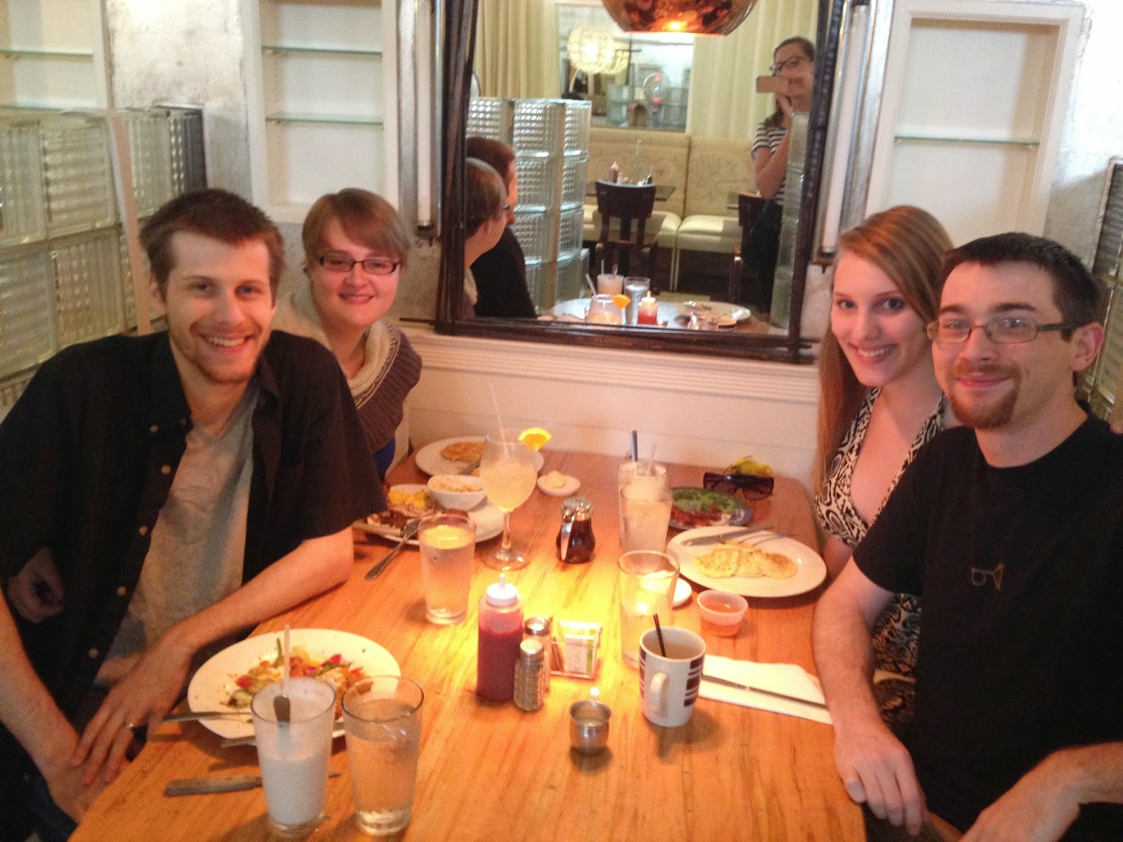
Lee*, Ana, Lee's sister, Lee's sisters boyfriend (left to right)

*It should be noted that my facial hair was only cultivated for the qualifying exam (this trip took place between the written and oral portions) and does not represent my current 'standard' appearance.  
Then we drove eight hours back, pausing for dinner at what proved to be a  profoundly Midwestern restaurant called Beef House. We were hoping based on the name (we had to go after seeing the billboards) that their beef would be superb but the best I can give them is workmanlike. The best thing from that dinner was the rolls, which they give you a free bag of when you leave. Overall, a brief but fun trip. If the place weren't so far away we'd certainly be up for going back more often.

Sunday, July 20, 2014

There is No Longer a Hole in the Side of the House

It went pretty well, all things considered. We spent a large portion of the day assembling the window frame for transport. This is the most complicated thing I've ever made from wood and it looks pretty good. With some additional cleaning, caulking, and touch-ups on the paint I think it will be pretty hard to see the defects from the inside. The outside, where I re-used mostly the original woodwork, retains many of the original gaps. They were previously filled with enormous beads of caulking, so we'll restore those in the next few days as well as add a metal rain guard over that bottom board (after priming and paint).

I made every piece of this except the glass and I assure you it could look so, so much worse than it does.  I custom ordered the glass so as to use as much of the existing hole in the siding as possible - this custom fit is why I spent the time to make a window frame from scratch. 

 Prepped hole in the house with blocks in place and nailed down to support the base of the frame.  The existing exterior facing was left in to make sure the frame couldn't fall outwards.  I admit I was very tense when we picked up the window and started moving it - I had spent better than two full days making that frame and I did NOT want to lose it.  Aside from the cat trying to trip Ana there was little drama in actually moving it.

This is with the window in place, shimmed, leveled, and fastened in place.  It looks crooked - it is not.  The framing below it is a little down to one side, but the framing will be invisible with the wall back on.  I checked many times. As planned, nobody on the outside can see into the shower area any more and we have a dramatically larger window (~25% larger in square inches but also without crossbars) than before to let in more light. This time it's centered, which is a major plus. It should be noted that with the old window there were blinds that always had to be on, which have been forever banished.  Win!

There is definitely some priming, painting, caulking, and cleanup work to do on the exterior but overall I would say it does not look screwed up.  There are a couple of sizable gaps but this part of the exterior faces the neighbors and is never seen so I'm OK with somewhat rougher work here.  Success!